Liberal Forum
Archive
‹
Political Chat Rooms
‹
The Water Cooler Chat Room
‹
Trump may have broken federal law by altering Hurricane Dorian's path on a map.
Trump may have broken federal law by altering Hurricane Dorian's path on a map.

By Nobody
4 Sep 2019 4:12 pm in The Water Cooler Chat Room

20 Jun 2025 11:20 am
Huh?

20 Jun 2025 11:37 am

*Huey » 04 Sep 2019, 4:15 pm » wrote: ↑ This is a joke, right?
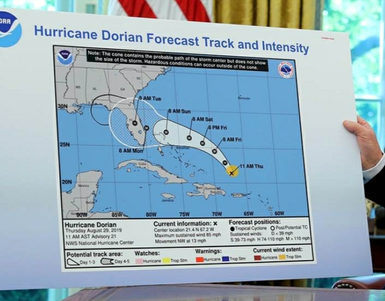
PS. Remember the last time you guys ranted about the AL comment I told you the original tracks had it crossing FL and heading to the Gulf. In a northwest direction? Look at the map and see where AL is. Seems to me you just down your own argument.
BV is in question time out indefinitely, until he takes the pledge to answer questions one for one.
The Pledge viewtopic.php?f=3&t=100927
Popular Vote Totals 2024 viewtopic.php?p=2685476#p2685476
BV's Sporter Losshttps: viewtopic.php?p=2610828#p2610828
BV 33 miles: viewtopic.php?p=2747521#p2747521
Sources viewtopic.php?p=2589152#p2589152
The Pledge viewtopic.php?f=3&t=100927
Popular Vote Totals 2024 viewtopic.php?p=2685476#p2685476
BV's Sporter Losshttps: viewtopic.php?p=2610828#p2610828
BV 33 miles: viewtopic.php?p=2747521#p2747521
Sources viewtopic.php?p=2589152#p2589152
20 Jun 2025 12:04 pm
A complete misrepresentation.
Again, when asked questions about this map, you ran.
20 Jun 2025 12:05 pm
Try that again.Blackvegetable » 20 Jun 2025, 12:04 pm » wrote: ↑A complete misrepresentation.*Huey » 20 Jun 2025, 11:37 am » wrote: ↑ This is a joke, right?
PS. Remember the last time you guys ranted about the AL comment I told you the original tracks had it crossing FL and heading to the Gulf. In a northwest direction? Look at the map and see where AL is. Seems to me you just down your own argument.
Again, when asked questions about this map, you ran.
BV is in question time out indefinitely, until he takes the pledge to answer questions one for one.
The Pledge viewtopic.php?f=3&t=100927
Popular Vote Totals 2024 viewtopic.php?p=2685476#p2685476
BV's Sporter Losshttps: viewtopic.php?p=2610828#p2610828
BV 33 miles: viewtopic.php?p=2747521#p2747521
Sources viewtopic.php?p=2589152#p2589152
The Pledge viewtopic.php?f=3&t=100927
Popular Vote Totals 2024 viewtopic.php?p=2685476#p2685476
BV's Sporter Losshttps: viewtopic.php?p=2610828#p2610828
BV 33 miles: viewtopic.php?p=2747521#p2747521
Sources viewtopic.php?p=2589152#p2589152
20 Jun 2025 12:07 pm
What did the map to which you make reference say about Dorian and Alabama?
20 Jun 2025 12:08 pm
Blackvegetable » 20 Jun 2025, 12:07 pm » wrote: ↑ What did the map to which you make reference say about Dorian and Alabama?
That’s a question. Sorry. That TRACK MAP projects Dorian moving NW over Fl towards the Gulf.
BV is in question time out indefinitely, until he takes the pledge to answer questions one for one.
The Pledge viewtopic.php?f=3&t=100927
Popular Vote Totals 2024 viewtopic.php?p=2685476#p2685476
BV's Sporter Losshttps: viewtopic.php?p=2610828#p2610828
BV 33 miles: viewtopic.php?p=2747521#p2747521
Sources viewtopic.php?p=2589152#p2589152
The Pledge viewtopic.php?f=3&t=100927
Popular Vote Totals 2024 viewtopic.php?p=2685476#p2685476
BV's Sporter Losshttps: viewtopic.php?p=2610828#p2610828
BV 33 miles: viewtopic.php?p=2747521#p2747521
Sources viewtopic.php?p=2589152#p2589152
20 Jun 2025 12:10 pm
Of course it is...*Huey » 20 Jun 2025, 12:08 pm » wrote: ↑ That’s a question. Sorry. That TRACK MAP projects Dorian moving NW over Fl towards the Gulf.
It makes my case, which is why you run like a little bitch.
20 Jun 2025 12:14 pm
Blackvegetable » 20 Jun 2025, 12:10 pm » wrote: ↑ Of course it is...
It makes my case, which is why you run like a little bitch.
you haven’t made a case. That track was 8 days out. Apart of the coast of AL are on the Hulf and NW of Fl ****.
BV is in question time out indefinitely, until he takes the pledge to answer questions one for one.
The Pledge viewtopic.php?f=3&t=100927
Popular Vote Totals 2024 viewtopic.php?p=2685476#p2685476
BV's Sporter Losshttps: viewtopic.php?p=2610828#p2610828
BV 33 miles: viewtopic.php?p=2747521#p2747521
Sources viewtopic.php?p=2589152#p2589152
The Pledge viewtopic.php?f=3&t=100927
Popular Vote Totals 2024 viewtopic.php?p=2685476#p2685476
BV's Sporter Losshttps: viewtopic.php?p=2610828#p2610828
BV 33 miles: viewtopic.php?p=2747521#p2747521
Sources viewtopic.php?p=2589152#p2589152

20 Jun 2025 12:33 pm
Great. And elections have consequences too, right? Anyway, I say let's all dwell on this as much as you **** retard libbies dwelled on the fact that biden killed 13 service members buy ignoring his generals.

6 Jul 2025 11:58 am
:rofl:*Huey » 07 Sep 2019, 7:27 pm » wrote: ↑ And exactly what problem do you have with that post whiny bitch?
Take a stand punk. Go on record.
Also, do you realize how wrong you are on this thread? Lil punk bitch I see how hard you are trying to changed the subject.

6 Jul 2025 12:04 pm

*Huey » 20 Jun 2025, 12:14 pm » wrote: ↑ you haven’t made a case. That track was 8 days out. Apart of the coast of AL are on the Hulf and NW of Fl ****.
I just called @Blackvegetable out about him refusing to take a stand on anything. Yet, he will demand everyone else to so he can unload his incessant stupid questions on them. **** narcissists. They are the worst human beings alive.
He does the same with:
- Questions. He demands answers to his questions, while refusing to answer any
- Evidence. He demands evidence for claims made, but refuses to provide any for his claims
- Taking a stand. He demands others to take a stand, while refusing to make one himself.
Blackvegatble's hypcorisy summed up in one post:
[/size]
Blackvegetable » 7 minutes ago » wrote: ↑7 minutes ago
Very simple questions...
From which you are running...

Blackvegetable » 7 minutes ago » wrote: ↑7 minutes ago
Very simple questions...
From which you are running...
6 Jul 2025 12:57 pm
Somebody is diverting like crazy.
BV is in question time out indefinitely, until he takes the pledge to answer questions one for one.
The Pledge viewtopic.php?f=3&t=100927
Popular Vote Totals 2024 viewtopic.php?p=2685476#p2685476
BV's Sporter Losshttps: viewtopic.php?p=2610828#p2610828
BV 33 miles: viewtopic.php?p=2747521#p2747521
Sources viewtopic.php?p=2589152#p2589152
The Pledge viewtopic.php?f=3&t=100927
Popular Vote Totals 2024 viewtopic.php?p=2685476#p2685476
BV's Sporter Losshttps: viewtopic.php?p=2610828#p2610828
BV 33 miles: viewtopic.php?p=2747521#p2747521
Sources viewtopic.php?p=2589152#p2589152
6 Jul 2025 4:26 pm
That's the thing about your stupid....it's ageless.
6 Jul 2025 4:28 pm
:rofl:*Huey » 04 Sep 2019, 4:15 pm » wrote: ↑ This is a joke, right?
PS. Remember the last time you guys ranted about the AL comment I told you the original tracks had it crossing FL and heading to the Gulf. In a northwest direction? Look at the map and see where AL is. Seems to me you just down your own argument.
6 Jul 2025 4:28 pm
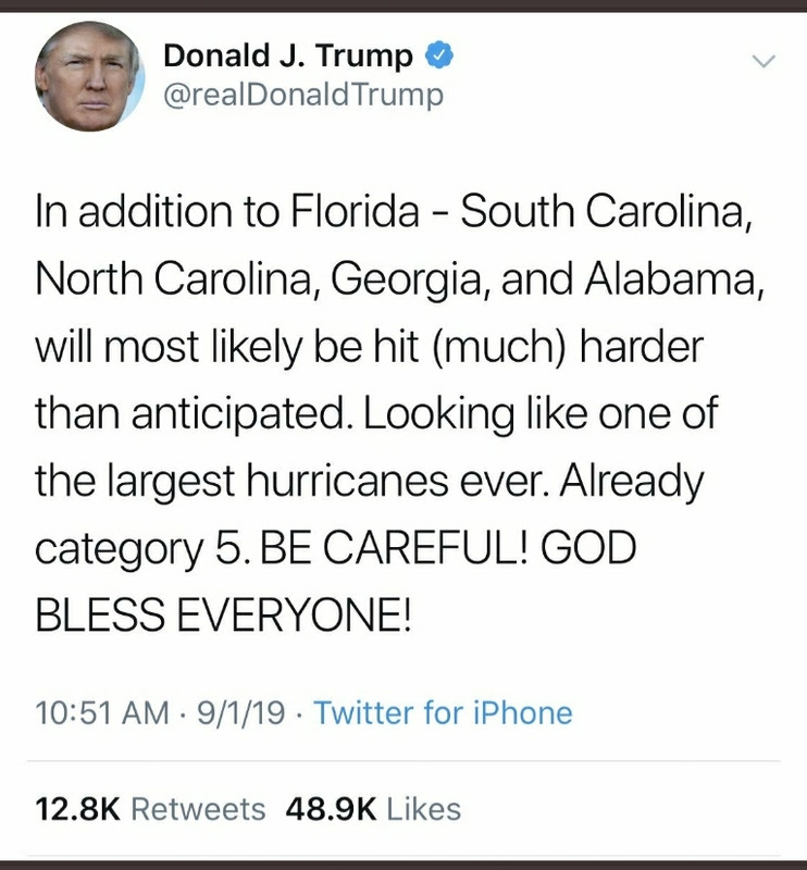
:die:*Huey » 04 Sep 2019, 5:50 pm » wrote: ↑ So you are serious.
Lmmfao! Impeach the ****!!!! Now.

You posted what I was talking about. Thank you. As one who lived above the panhandle when a cat 5 has that track ya pay attention.

6 Jul 2025 4:32 pm
*Huey » 05 Sep 2019, 12:20 pm » wrote: ↑ Sorry, the track on the map has the storm heading over lake Okeechobee towards the northwest and the gulf. That track if it continued place alabama on the outer bands or what was at the time a CAT 5 hurricane. So it is correct that alabama at the time of that track was in the cone to be hit.
You wanna discuss stupid? Look in the mirror and see your face.
this **** is epic...
6 Jul 2025 6:23 pm
Nobody » 04 Sep 2019, 4:12 pm » wrote: ↑
Just saw him on TV still sticking with his lie that Alabama was in the original forecast.
And the King of the black sharpie has no idea how that black mark got on the map.
The man is so incapable of ever admitting he was wrong about anything that it looks like he may have altered an official NOAA map, which is illegal.
The original Tweet:
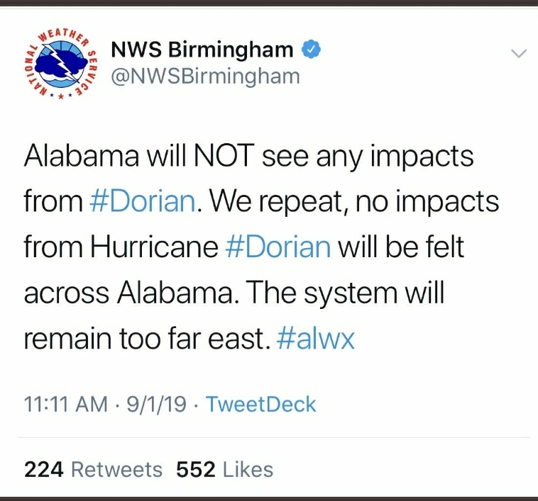
The Birmingham National Weather Service correction:
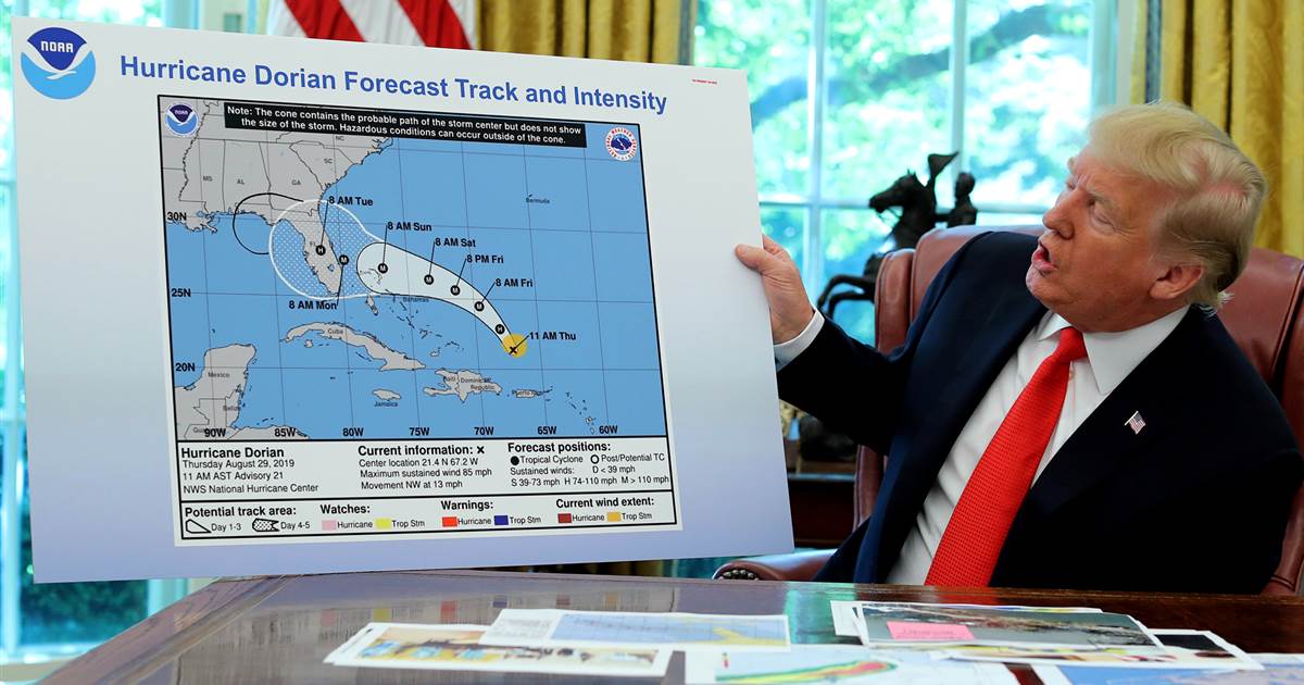
**** off you deranged ***.
6 Jul 2025 6:23 pm
You eat epic ****.
7 Jul 2025 5:03 am
Still diverting from another curbstomping I see.
BV is in question time out indefinitely, until he takes the pledge to answer questions one for one.
The Pledge viewtopic.php?f=3&t=100927
Popular Vote Totals 2024 viewtopic.php?p=2685476#p2685476
BV's Sporter Losshttps: viewtopic.php?p=2610828#p2610828
BV 33 miles: viewtopic.php?p=2747521#p2747521
Sources viewtopic.php?p=2589152#p2589152
The Pledge viewtopic.php?f=3&t=100927
Popular Vote Totals 2024 viewtopic.php?p=2685476#p2685476
BV's Sporter Losshttps: viewtopic.php?p=2610828#p2610828
BV 33 miles: viewtopic.php?p=2747521#p2747521
Sources viewtopic.php?p=2589152#p2589152
7 Jul 2025 5:03 am
Obviously maps are not your schtick, Cubicle.
BV is in question time out indefinitely, until he takes the pledge to answer questions one for one.
The Pledge viewtopic.php?f=3&t=100927
Popular Vote Totals 2024 viewtopic.php?p=2685476#p2685476
BV's Sporter Losshttps: viewtopic.php?p=2610828#p2610828
BV 33 miles: viewtopic.php?p=2747521#p2747521
Sources viewtopic.php?p=2589152#p2589152
The Pledge viewtopic.php?f=3&t=100927
Popular Vote Totals 2024 viewtopic.php?p=2685476#p2685476
BV's Sporter Losshttps: viewtopic.php?p=2610828#p2610828
BV 33 miles: viewtopic.php?p=2747521#p2747521
Sources viewtopic.php?p=2589152#p2589152
Who is online
In total there are 2965 users online :: 11 registered, 16 bots, and 2938 guests
Registered users: Johnny You, *Roshambo, Blackvegetable, ROG62, RebelGator, ConservativeWave, FJB, MR-7, Deezer Shoove, 31st Arrival, Huey
Bots: facebookexternalhit, Kinza, TTD-Content, Not, LCC, Applebot, ADmantX, YandexBot, proximic, Googlebot, CriteoBot, GPTBot, Mediapartners-Google, linkfluence.com, bingbot, curl/7