Liberal Forum
Archive
‹
The Water Cooler Chat Room
‹
Trump may have broken federal law by altering Hurricane Dorian's path on a map.
4 Sep 2019 7:17 pm
I was not talking about the spaghetti model from August 28th.Lucifershammer » 04 Sep 2019 6:40 pm » wrote:It's called a spaghetti model nobody added lines that's what they look like.Misty » 04 Sep 2019 6:38 pm » wrote:Yes. I am seeing that someone drew a black line with a sharpie on a map that Trump displayed TODAY to make it look like Alabama is still within the cone of the storm.
And FYI, I'm not the only one who can see that.
Use the Google.
And BTW have you seen what it says under that map?

The whole thing causes me nothing but confusion.
I am talking about the map that the POTUS held up TODAY.
In order to make it look like Trump was right when he Tweeted on Sept. 1st that Alabama would take a hit by Dorian, someone drew a line in black sharpie on this map from August 29th to make it look like the cone of the storm included Alabama.
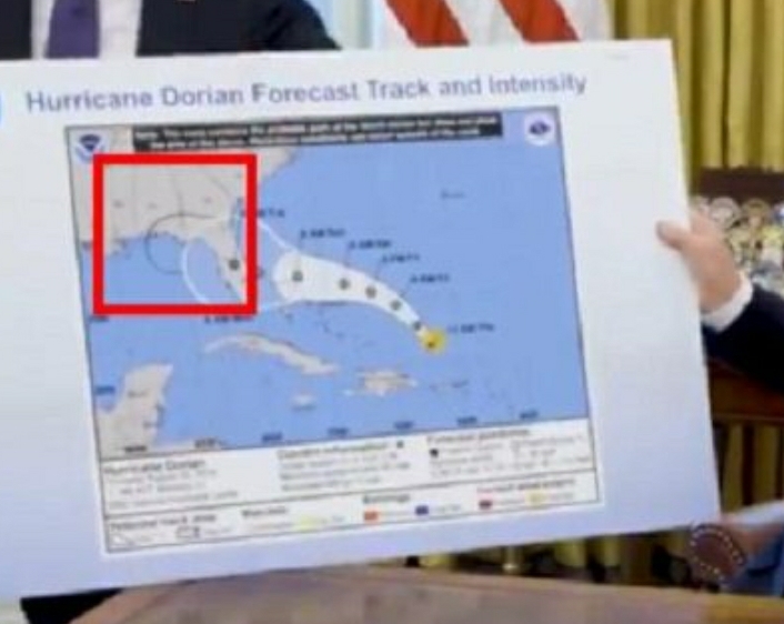
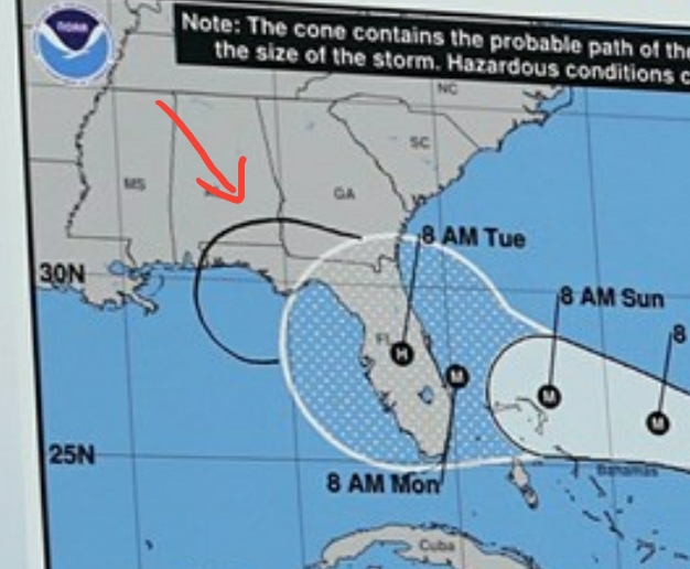
NOAA does not update their maps in black sharpie.
But the POTUS is famous for using a black sharpie.
And apparently alter weather maps too.Trump told Sharpie to create a custom pen for him to sign important documents.
Trump is known for his signature writing tool — the Sharpie pen.
In fact, his thick and highly legible Sharpie scrawl has caused problems for the president in the past — giving away notes to his speech and making some of his private thoughts visible to the public.
Despite this, he has continued to use the Sharpie to sign executive orders, mark up drafts of important speeches, and add notes like "a teacher marking a quiz," Guardian writer Sam Wolfson wrote in July.
